Case study

"Transboundary: Integrated Flood and Drought Management for Climate Change Adaptation in the Volta Basin":

hydro-meteorological model Volta
Summary

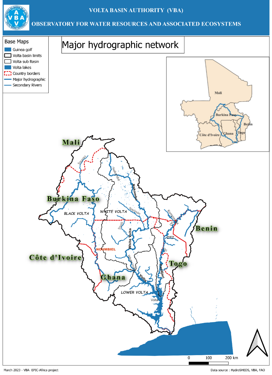
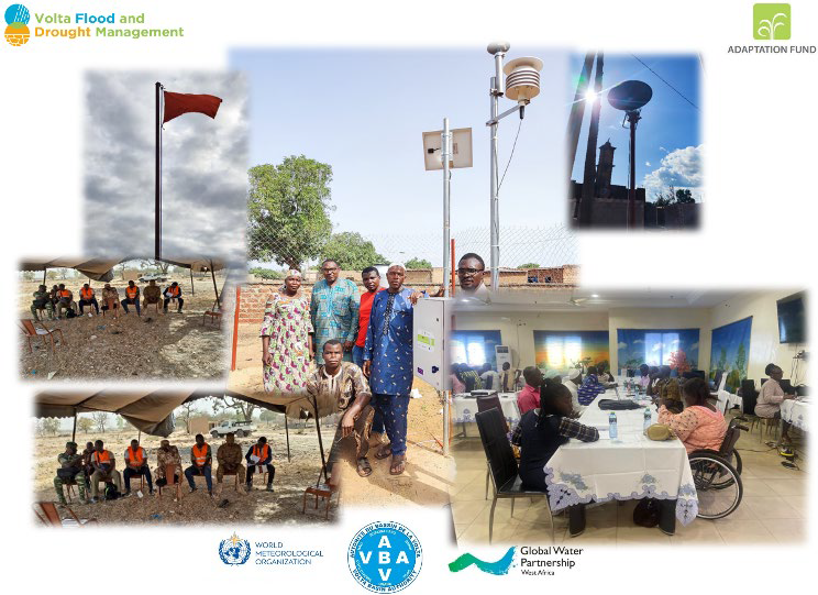
The Volta Basin is highly vulnerable to climate-related hazards (floods and droughts). The VFDM Project, funded by the Adaptation Fund and implemented by a consortium of partners including WMO, VBA, and GWP-WAF from June 2019 to June 2024, aimed to: Develop capacities and frameworks at local, national, and regional levels to support informed climate risk decision-making; Implement concrete and environmentally sound climate adaptation actions, including nature-based solutions through an integrated approach; Strengthen political and institutional capacities for integrated flood and drought management at local, national, and transboundary levels. 

Background

The Volta Basin, spanning six West African countries—Benin, Burkina Faso, Côte d'Ivoire, Ghana, Mali, and Togo—is one of the most vulnerable regions in West Africa due to high climate variability and limited adaptation capacity. The basin experiences extreme weather including heatwaves, erratic rainfall, floods, and prolonged droughts, adversely impacting agriculture, pastures, and water resources. These challenges are compounded by growing security risks.

Volta Basin Map

In response, the  “Integrating Flood and Drought Management and Early Warning for Climate Change Adaptation in the Volta Basin” (VFDM Project) was launched by VBA, GWP-WAF, and WMO with Adaptation Fund support, to deliver the first large-scale transboundary implementation of integrated flood and drought management strategies and end-to-end early warning systems.

Actions taken

Objectives

The main goal was to strengthen integrated flood and drought risk management and early warning systems in the Volta Basin. Specific objectives included:

  1. Improving risk knowledge;
  2. Enhancing prevention and management frameworks;
  3. Supporting concrete adaptation actions and stakeholder involvement;
  4. Strengthening institutional capacities at all levels.

Target Groups and Beneficiaries

The initiative targeted government ministries overseeing water and disaster management, national agencies (meteorology, hydrology, civil protection, etc.), NGOs, and local flood/drought management committees. Nearly 23 million rural people, youth practitioners, and scientists were direct beneficiaries.

Methodology

The project followed a participatory and inclusive approach, leveraging national expertise, promoting nature-based solutions and gender-sensitive planning. Implementation was phased:

  1. Start-up: Institutional arrangements and operational tools developed.
  2. Execution: Studies, trainings, workshops, equipment acquisition, and pilot actions rolled out.
  3. Capitalization: Results were documented, shared, and promoted.
  4. Resource mobilization: Engagement with technical and financial partners to support scaling.

Key Activities 

Component 1 – Capacity Development:

  • National assessments on risk management capacity;
  • Participatory hazard and vulnerability mapping;
  • Development of risk profiles and regional strategy (2025–2030);
  • Selection of six vulnerable pilot sites for community-based actions.

simulation training

Component 2 – Concrete Adaptation Actions:

  • Deployment of the myDewetra-VoltAlarm early warning platform;
  • Installation of hydromet equipment;
  • Training on gender-sensitive early warning systems and nature-based solutions;
  • Database development for each country;
  • Implementation of pilot community management initiatives.

Component 3 – Institutional Capacity Strengthening:

  • Training of local and national institutions;
  • Identification and dissemination of good practices;
  • Community involvement frameworks established.

    monitoring station in Burkina

Outcomes

Results and Achievements

Enabling Environment (Dimension 1):

  • Regional strategy and action plans were created;
  • Gender and community participation frameworks were developed.

Institutions and Participation (Dimension 2):

  • Over 215 individuals trained (including 101 women);
  • Cross-sector collaboration improved between hydrology, meteorology, agriculture, etc.;
  • Community committees established and trained.

Community committees on flood management

Management Instruments (Dimension 3):

  • Enhanced access to risk data and forecasts;
  • Development of flood and drought risk maps;
  • Expansion of observation networks.

Financing (Dimension 4):

  • A concept note (PRECCOM-BV) was developed to attract funding for ecosystem and community resilience.

Impacts

Notable impacts include:

  • Improved early warning response reducing human and material losses;
  • Increased community resilience;
  • Strengthened technical capacities and institutional collaboration.
Lessons Learned

Lessons Learned and Success Factors

  • National working groups and participatory approaches were vital;
  • Using known local NGOs improved pilot project success;
  • Local ownership and smart practices (climate-smart approaches) were embraced;
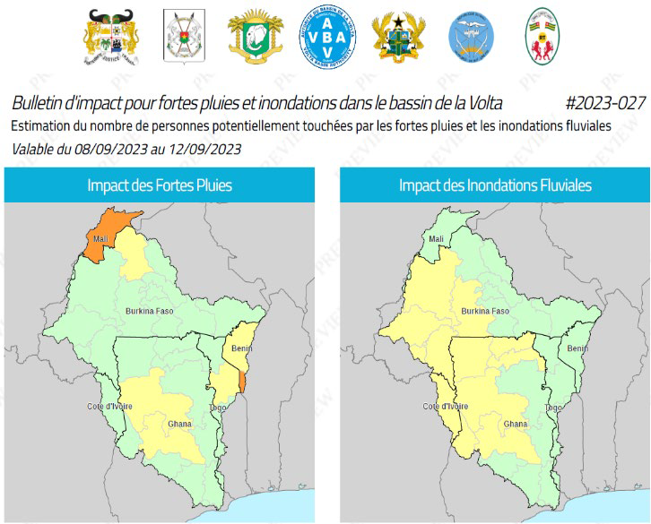
  • Tools like the VOLTALARM platform were instrumental;
  • Local authorities’ engagement enhanced legitimacy and scaling potential.

Conclusion and Recommendations

The initiative created a favorable political, technical, and social environment for integrated risk management in the Volta Basin. For broader impact, it is crucial to:

  • Support local adoption and scaling of results;
  • Secure additional financing;
  • Launch a second project phase to consolidate and expand efforts.

Source URL:https://droughtclp.unccd.int/case-study/transboundary-integrated-flood-and-drought-management-climate-change-adaptation-volta